Historic Circa 1790s Pennsylvania Land Survey Plat Map Manuscript Document with Provenance to Surveyors William Ellis and John Adlum
An exceptional, original late 18th-century handwritten American land survey plat map, traditionally known as a surveyor draught, from Pennsylvania. This authentic manuscript document features metes-and-bounds charting, detailed acreage calculations, and a fascinating period administrative correction. The document directly names adjacent tract boundaries belonging to prominent early American surveyors and historic land speculators William Ellis and John Adlum. This document is a prime artifact from the post-Revolutionary War Pennsylvania land speculation boom of the 1790s.
John Adlum lived from 1759 to 1836 and was a Revolutionary War veteran, major district surveyor, and land agent who famously surveyed upstate Pennsylvania boundaries. He later achieved fame as a pioneering viticulturist, widely recognized today as the Father of American Viticulture. William Ellis was a prominent Quaker surveyor who partnered extensively with John Adlum and Samuel Wallis in surveying and managing massive land tracts in the Muncy, Lycoming County, and West Branch Susquehanna regions.
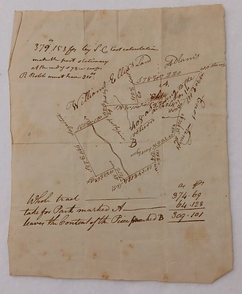
The front of the manuscript shows a hand-drawn geometric plat map dividing a large tract of land into sections labeled A and B. It features classic early survey terminology referencing living landmarks and physical features, including a Sugar tree along a sinuous stream boundary, a white pine, and a White Oak stump noted as a w.o. stump. It clearly notes period survey coordinates along the perimeter lines such as S 63 W 120 and S 27 E 144.
This document captures a rare, real-time 18th-century administrative dispute. The map originally claimed the upper section held 408 acres according to the return. However, a bold period hand has heavily crossed through the plot with a large letter B and added the corrective note stating only 309 by two honestly lines. The bottom panel contains a beautifully penned ink calculation grid adjusting the final acreage figures to Whole tract 374.69, Part A 64.128, leaving Part B at 309.101.
When folded for historical archival storage, the outer panel was custom-endorsed by the auditing clerk or surveyor with a stark, prominent ink notation reading a draught as returned / wrong. This explicit dismissal perfectly links to the front-page boundary adjustments, marking this as an officially voided or corrected surveyor draft.
This piece dates to the circa 1790s era and originates from Pennsylvania, USA. It is written in dark iron gall ink on handmade rag laid paper, and faint pencil calculations are visible on the reverse panels from the field auditor. The item is in very good antique condition. The paper remains strong with a beautiful, natural age patina. It features expected historical fold lines with minor iron staining and light embedded dust along the old creases, which adds immense archival character. There is no major tattering or text loss, and it remains highly legible. This is a museum-grade piece of early American cartography and land speculation history, perfect for collectors of Pennsylvania history, early surveying artifacts, or unique legal ephemera.

Related Items:
1790s Pennsylvania Colonial Land Speculation Plat Map Hand Drawn Bounds Map
$425.00
1790s Lancaster PA Promissory Note, Harter Family and W. Rhoads, W/ Jacob Irish
$261.25

Postcard Postcard: Holz-Masse doll with 1790s PA Dutch wagon
$15.95